DXF Export/import
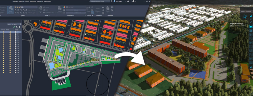
Our DXF exporter allows exporting polygons, colors and categories, including a geo-location. This simplifies your workflow for uploading urban plans in Tygron as follows:
- Build a new project in Tygron using the ‘Tygron DXF template’ . A geoplugin based on the NLCS standard of urban plans then becomes available in your project. See for more information:
https://www.infracad.nl/images/Formele-beschrijving-NLCS-versie-4_0-01-11-2014.pdf - You can now export the project location including surroundings and the standard layers from the Tygron GeoPlugin.
- You can use this in AutoCAD either as a ‘coloring plate’ to start drawing your urban plan, or you can import an existing AutoCAD design here and connect it to the layers available in the DXF.
- You can now import the urban plan into Tygron without having to worry about the correct geo-reference or naming of functions.
Some benefits of this approach:
- Objects like buildings and roads will be exported to the DXF file so that the user has a context of his surroundings in AutoCAD.
- The DXF file is automatically geo-referenced to the project CRS.
- AutoCAD layers are automatically generated based on the Geo Plugin used in Tygron so that when importing the design back to Tygron, the layers will match the Tygron Functions, and the AutoCAD design is shown directly in 3D and its properties can be used for calculations in Tygron.
Watch the tutorial on how to do this here: