Ability to perform scheduled update during testrun
When creating a project with complex calculations, the calculation time may require a user to use a scheduled update rather than a direct calculation, so that it can be run […]
Select your own GPU cluster (down only)
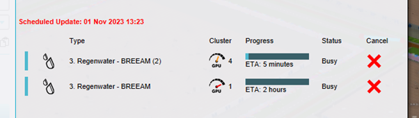
I want to be able to pick my GPU cluster in Tygron. For specific calculations with water models the biggest cluster can take significantly longer then the less extreme cluster. […]
Allocating GPU cluster to calculation manually by user
In live sessions with stakeholders and “future design” functionalities performance can be very important. It is possible that the “sprint GPU” is far superior in performance (50x faster) then the […]
FEATURE REQUEST – User-friendly method of exporting result of spatial calculations as images
As a data creator/analist, I would like a user-friendly way to export the results of overlays as images, so that it becomes easier to convert the raw calculated results to […]
Dynamic Modelling Tracer flow model
The ability to control (via CSV) the emission of tracers over time and if possible also adjust the quantity. For example peak pollution of oil is not constantly emitting, but […]
Import RAIN_AREAS via geotiff (instead of geojsons)
When using the option of RAIN_AREAS I usually have a Tiff-file. Now I have to convert this Tiff-file to a multipolygon (geojson). It would be nice if this wasn’t necessary […]
Ability to import floors when importing constructions
As a planning analist, I would like the ability the import geojsons (or other geodata sources) as constructions for measures with a specific floor height, so that I can import […]
Air quality calculations: add PM2.5
The possibility to calculate PM2.5 based on traffic intensity, in addition tot the existing PM10 calculations. PM2.5 is more related to traffic intensities.
Return to the main menu menu when closing a project.
The ability to return to the main menu without closing the entire application when closing a project. This will prevent the user the effort of restarting and re-logging in when […]
Import terrains as measures
When importing a spatial plan in the Geo Data Wizard, often terrains (water) are part of the plan. It would be convenient to import the whole plan (buildings and terrains) […]
