When: May 12, 2026 from 9:30AM – 12:00AM
Location: DMI-centre
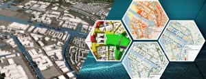
This session is intended for area developers, urban planners, and spatial planners: generate a digital model of a city or neighborhood, load urban development plans into it, evaluate them based on KPIs, and present the results clearly. The workflow for spatial plans and urban development scenarios has been further optimized. This makes the platform more compatible with planning processes in municipalities and design teams. During this session, you can get hands-on with the new functionalities under supervision:
- Direct import of designs and measures via IFC files (BIM) and AutoCAD formats.
https://previewsupport.tygron.com/wiki/How_to_import_an_IFC_file - Simplified coordinate conversion, without a separate step via ArcGIS Pro.
https://previewsupport.tygron.com/wiki/How_to_export_Sketchup_models_to_IFC
https://previewsupport.tygron.com/wiki/How_to_export_Blender_models_to_IFC - Ability to smooth the underlying elevation model for new construction.
https://previewsupport.tygron.com/wiki/How_to_remove_a_waterway_from_the_heightmap - Full QGIS support via WFST, including editing of waterways and other features.
https://previewsupport.tygron.com/wiki/How_to_edit_your_project_data_via_WFS - Faster scenario calculations thanks to the new limit map, which only requires calculations for a sub-area.
https://previewsupport.tygron.com/wiki/How_to_use_a_limit_map_in_a_Scenario - Indicator results are saved per scenario, making it easy to compare variations.
- Support for dashboarding and visual scoring of measures via open-source dashboards.
https://github.com/Tygron/tygron-dashboard