Water Board Vechtstromen was faced with the task of setting standards for its flood defenses. In total, the water board has 400 km of flood defenses. The key questions that needed to be answered are:

Water
What is a suitable standard for the flood defenses?
What are the consequences if a flood defense fails?
To answer these questions, the water board built a tool on the Tygron Platform. Jeroen van der Scheer, hydrologist at the Vechtstromen water board: "It was not a foregone conclusion beforehand that we would use the Tygron Water Module for these calculations. It was the result of the pilot that we naturally arrived at the Tygron Water Module."
Selection of the tool
For standardizing the flood defenses, the water board opted for the risk approach. The standard a flood defense receives depends on the consequences of a potential flood. Therefore, a flood defense receives a higher standard when the consequences of a failing flood defense are greater.
To establish the correct method for standardizing the flood defenses, the Water Board conducted a pilot study in collaboration with the consultancy firm DIJK53. The guiding principles under which the standards are established came from the pilot study. Some of the guiding principles are:
NBW standard1 is the starting point.
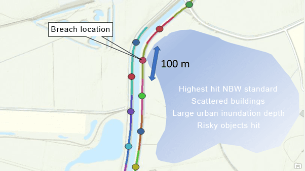
Simulate a failure every 100 meters.
Include breach growth according to the van der Knaap formula.
Risk objects are objects such as schools and hospitals.
To investigate 400km of flood defenses, thousands of flood calculations had to be performed and the impact of the flooding analyzed. From this arose the question: can this be automated?
Based on this automation question, experts from the water board arrived at the Tygron Water Module. The advantage of the Tygron Water Module is that it is a robust tool with a clear data structure. Calculations can be performed once via a script and are consistent and reproducible. In addition, the tool delivers exactly the data needed, not too much and not too little.
How does the tool work?
In this video, Jeroen van der Scheer and Rudolf Koster explain together how the tool works:
The tooling consists of a script that prepares the projects and automatically breaches the flood defense every 100 meters. For each breach, the following is calculated and exported:
How much water is in which location.
To what extent that overlaps with the water board's standards map.
Which risk objects in the area are affected, broken down into different categories.
The tooling is reusable for other water boards. An example of its use is also available in our Python SDK. The user can set the guiding principles under which calculations must be made, and the tooling is then fully self-operable.
1. NBW is National Agreement on Water (Nationaal Bestuursakkoord Water)

