Ga naar de inhoud
Meld je aan voor onze verdiepingssessies over de nieuwe functionaliteiten in "LTS 2026"
Meld je aan
Thema’s
Digital Twin
Stedenbouw
Klimaatbestendigheid
Milieu-impact
Waterveiligheid
GIS en data-analyse
Kenniscentrum
Functionaliteiten
Licentiemodel
Blogs
Webinars & Events
Tygron Academy
Onderwijs licentie
Over Ons
Over Tygron
Neem Contact op
Vacatures
Support
EN
Menu
Thema’s
Digital Twin
Stedenbouw
Klimaatbestendigheid
Milieu-impact
Waterveiligheid
GIS en data-analyse
Kenniscentrum
Functionaliteiten
Licentiemodel
Blogs
Webinars & Events
Tygron Academy
Onderwijs licentie
Over Ons
Over Tygron
Neem Contact op
Vacatures
Support
EN
Neem contact op
december 5, 2023
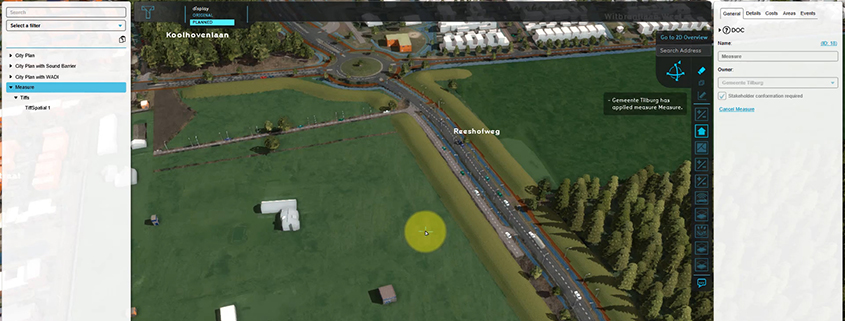
Adding a GeoTIFF to a measure
Roadmap
Adding a GeoTIFF to a measure
1
2 jaren ago
tygron
Released on Preview 2024
0
Attachment
Feature
Adding a GeoTIFF to a measure
Very useful for e.g. including a new height map in a measure – for calculating the impact of an urban plan on water nuisance.
Documentation:
https://previewsupport.tygron.com/wiki/How_to_add_a_GeoTIFF_to_a_measure
Zoek
Zoek
Related posts
Weging van het waterbelang: bouwen met het watersysteem
Lees meer
Van ontwerp tot impact: TAUW over klimaatadaptief inrichten met Tygron
Lees meer
De relevantie van digital twins voor gemeentelijke opgaven
Lees meer
Gestandaardiseerde hittestressanalyses voor Amsterdam
Lees meer
Verslag Community of Practice 2025
Lees meer
Privacy Preferences
When you visit our website, it may store information through your browser from specific services, usually in form of cookies. Here you can change your privacy preferences. Please note that blocking some types of cookies may impact your experience on our website and the services we offer.
I Consent
Required